Miami, September 27 (RHC)-- As Tropical Storm Karen withers away, Hurricane Lorenzo has become “one of the largest and most powerful hurricanes of record for the tropical central Atlantic,” according to the National Hurricane Center.
Now packing 140 mph winds, Lorenzo has become a Category 4 storm farther east than any other previous storm on record, save for Julia in 2010. While far from any populous land masses at the moment, Lorenzo could be having an impact on the Azores in less than a week’s time — all the while marking a potentially ominous climate signal.
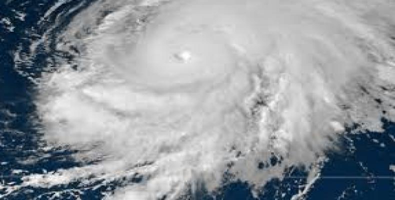
The Category 4’s sprawling cloud shield spans more than 1,000 miles — roughly the distance from Washington, D.C., to Miami; including its outflow, it would be large enough to cover the entire East Coast beneath overcast.
Hurricane Lorenzo's eye has become a bit more poorly defined in the most recent satellite imagery, but it's expected that Lorenzo will remain a major hurricane through the weekend.
Lorenzo had the makings of a top-tier storm from the start. The National Hurricane Center delineated it as an area to watch, with a “likely” chance of development, even while it was still a mere tropical wave over the African continent.
Lorenzo quickly bloomed immediately after exiting the African coast for the tropical Atlantic Ocean, becoming a tropical storm around lunchtime Monday. Its rate of strengthening has been notable.
At 5 a.m. Wednesday, Lorenzo was declared the fifth Atlantic hurricane of the 2019 season. A day later, the National Hurricane Center announced that it had “rapidly [strengthened] into a major hurricane.” By Thursday midmorning, Lorenzo was a Category 4, its winds having jumped from 85 mph to 130 mph in 24 hours.
Lorenzo is expected to maintain strength or gradually decline in peak winds over the coming days, but it will remain a dangerous major hurricane through the weekend. By the middle of the workweek, Lorenzo could affect the Azores, a remote island chain owned by Portugal.
For the time being, Lorenzo’s dance is just a show for meteorologists. But beneath the surface, it is the latest overachieving storm to fit into a pattern ripe with overachieving storms.
A summary of available research from NOAA’s Geophysical Fluid Dynamics Laboratory notes that “tropical cyclone intensities globally will likely increase.” An increase in the most intense tropical cyclones, Category 4s and 5s, may already be underway. Each of the past four Atlantic hurricane seasons has featured at least one Category 5.